CHAPTER 02
Solar geometry.
Coordinate systems, time conventions and equations used to locate the sun relative to a building at any date and time. Chapter 03 uses it to draw shadows by hand, Chapter 04 turns it into sun-path diagrams, shading masks and shadows, and Chapter 05 into solar radiation on surfaces.
DESIGN QUESTIONS · SYMBOLS
Purpose and nomenclature
Solar geometry answers three design questions: which surfaces receive direct sun and when; where shadows fall; how far sun penetrates through an opening.
Angles use Szokolay's three-letter abbreviations. Colors are the same in text, equations and drawings: altitude, azimuth and horizontal angles, zenith, latitude and vertical shadow angle.
| Symbol | Quantity | Definition and range | Eq. |
|---|---|---|---|
| LAT | Latitude | Angle north (+) or south (−) of the equator. −90° to +90°. | — |
| LONG | Longitude | Angle east or west of Greenwich. Given here in °W. | 2 |
| NDY | Day number | Day of the year, 1 (Jan 1) to 365. | 3, 4 |
| DEC | Declination | Angle between the earth–sun line and the equatorial plane. −23.45° to +23.45°. | 4 |
| EOT | Equation of time | Apparent minus mean solar time. About −14 to +16 min. | 3 |
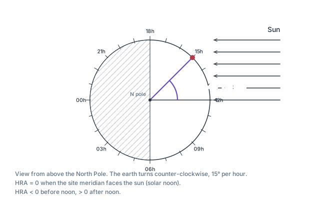
| HRA | Hour angle | Rotation of the site meridian from solar noon. 15° per hour; negative before noon. | 6 |
| ALT | Solar altitude | Angle of the sun above the horizon. 0° to 90°. | 5, 7 |
| ZEN | Zenith angle | Angle from the vertical. ZEN = 90° − ALT. | 10 |
| AZI | Solar azimuth | Horizontal direction of the sun, from north, clockwise: 0° to 360° (east 90°, south 180°, west 270°). | 8 |
| ORI | Orientation | Azimuth of the outward normal of a surface (south facade: 180°). | 16, 25, 26 |
| HSA | Horizontal shadow angle | AZI − ORI. Sun reaches the facade only if |HSA| < 90°. | 16 |
| VSA | Vertical shadow angle (profile angle) | Sun altitude projected onto a vertical plane perpendicular to the facade. | 17 |
| INC | Angle of incidence | Angle between the sun ray and the surface normal. | 18, 23, 26 |
LATITUDE · LONGITUDE
Site coordinates
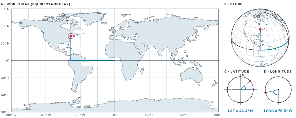
A site is located by LAT and LONG. Ithaca: 42.4° N, 76.5° W.
- Latitude sets the geometry of the sun paths: noon altitude, day length, sunrise and sunset azimuths. All diagrams in this chapter depend on it.
- Longitude does not change the sun paths. It only shifts clock time relative to solar time (section 03).
SKY HEMISPHERE · EQ. 10
Altitude and azimuth
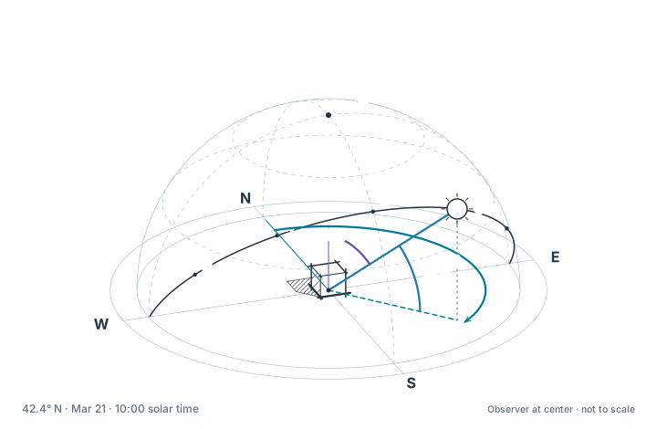
Sun rays at a building are treated as parallel. The sun's position seen from the site is given by two angles on the sky hemisphere centered on the observer.
- ALT · altitude
- Vertical angle between the horizon and the sun ray. 0° at sunrise and sunset, 90° at the zenith. Negative values: sun below the horizon.
- AZI · azimuth
- Horizontal angle from true north, measured clockwise, to the vertical plane through the sun.
- ZEN · zenith angle
- Angle between the vertical and the sun ray.
CURRENT SUN
- ALT
- —
- ZEN
- —
- AZI (from N, clockwise)
- —
Azimuth is always measured from north, clockwise: east 90°, south 180°, west 270°. Facade orientation (ORI) uses the same scale.
TIME ZONES · EQ. 1
Standard time and solar time
- Apparent solar time
- Time defined by the actual sun. Solar noon (12:00) is the instant the sun crosses the local meridian; HRA = 0. North of the Tropic of Cancer the sun is then due south (AZI = 180°); south of the Tropic of Capricorn due north; between the tropics it may be either.
- Standard time
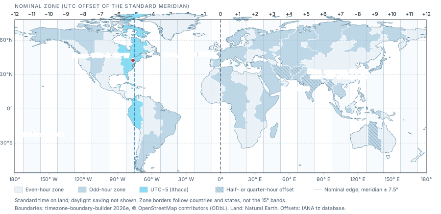
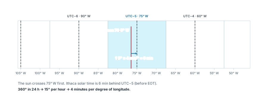
- Clock time of a time zone. Zones are nominally 15° wide and use the time of a standard meridian (a multiple of 15°). Eastern Standard Time, UTC−5: 75° W.
- Daylight saving time
- Standard time + 1 h. Eastern Daylight Time: UTC−4.
The earth turns 360° in 24 h. One degree of longitude therefore corresponds to
Ithaca is 1.5° west of the 75° W standard meridian. The sun crosses Ithaca's meridian 1.5 × 4 = 6 min after it crosses 75° W. All sun-path diagrams, sundials and the equations in section 07 use solar time.
VALUES FOR THE CITY · EQ. 2 WITHOUT EOT
ΔT = Tsolar − Tstandard, longitudes in °W. Solar noon is given in standard time.
SEASONS · TILT · DISTANCE
Earth's orbit and the seasons
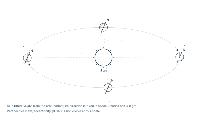
- The orbit is nearly circular: closest to the sun about Jan 3 (147.1 million km), farthest about Jul 4 (152.1 million km).
- The rotation axis is tilted 23.45° from the normal to the orbital plane. Its direction is fixed in space.
- The seasons are caused by the tilt, not by the distance. The northern hemisphere is closest to the sun in winter.
Three effects of the tilt
- Noon altitude changes by ±23.45° about its equinox value (section 06).
- Day length changes (Eq. 9). At 40° N, the Dec 21 day is about 6 h shorter than the Jun 21 day.
- Irradiance on the ground changes: the low winter sun spreads its beam over a larger area and its path through the atmosphere is longer. Chapter 05 turns this into the cosine law and the radiation on any surface.
ANALEMMA · EQ. 2–3
Equation of time and time conversion
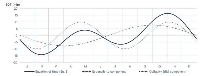
The equation of time (EOT) is the difference between apparent solar time and mean solar time.
- Two causes: the orbital speed varies with distance (eccentricity component, one cycle per year); the tilt of the axis relative to the orbital plane (obliquity component, two cycles per year).
- Range: about −14.2 min (around Feb 11) to +16.4 min (around Nov 3).
Clock time to solar time
INPUT
Example: Feb 25, 11:30 EST, Ithaca. Eq. 3 gives EOT = −13.5 min, so Tsolar = 11:30 − 6 − 13.5 = 11:10.5.
Analemma
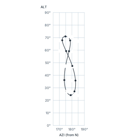
If the sun is recorded at the same clock time every day, its positions form a figure-eight. The vertical extent is the change in declination (section 06); the horizontal extent is the equation of time.
READING THE FIGURE-EIGHT
Clock time depends on longitude: set the site and its time-zone meridian together, or pick a location. At Ithaca in February the sun is east of south at 12:00 EST (late); in November it is west of south (early). Every 1° the site lies west of its zone meridian shifts the whole figure 4 min later (Eq. 2). South of the equator the figure faces north.
MERIDIAN SECTION · EQ. 4–5
Declination and noon altitude
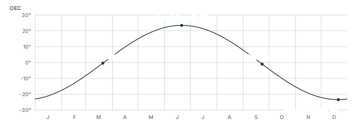
DEC is the angle between the earth–sun line and the equatorial plane. It equals the latitude at which the sun is in the zenith at noon (the subsolar point).
| Reference date | DEC | Subsolar latitude |
|---|---|---|
| Mar 20/21 · March equinox | 0° | Equator. Day = night everywhere. |
| Jun 21 · June solstice | +23.45° | Tropic of Cancer. Polar day north of 66.55° N. |
| Sep 22/23 · September equinox | 0° | Equator. |
| Dec 21/22 · December solstice | −23.45° | Tropic of Capricorn. Polar night north of 66.55° N. |
Noon altitude
At solar noon the sun, the site and the earth's axis lie in one plane: the meridian section. In this section the zenith angle at the site equals the angle at the earth's center between the site and the subsolar point, |LAT − DEC|. Hence
For LAT > 23.45° N this is 90° − LAT + DEC. Between solstices the noon altitude changes by 2 × 23.45° = 46.9°.
SUN POSITION · EQ. 6–9
Hour angle, altitude and azimuth
Three inputs give the sun position at any time: LAT (site), DEC (date, Eq. 4), HRA (solar time, Eq. 6).
Eq. 8 gives azimuth from north. arccos returns 0°–180° only, so it cannot distinguish morning (east) from afternoon (west); the branch rule fixes this. The three terms of Eq. 7 and 8 are the components of a unit vector S pointing at the sun:
EQ. 4, 6, 7, 8 WITH CURRENT VALUES
Sunrise, sunset and day length
At sunrise and sunset ALT = 0, so the bracket in Eq. 7 is zero:
If −tan LAT · tan DEC < −1 the sun does not set (polar day); if > 1 it does not rise (polar night). Sunrise is at 12:00 − HRAss/15 solar time.
All together: orbit, EOT, DEC and the noon section
Four drawings of sections 04–06 driven by one latitude and date, all at solar noon (HRA = 0). The date moves the earth along its orbit and the markers on the EOT and DEC curves, and tilts the meridian section. Press Play year and watch DEC and the noon altitude follow the earth around the sun, while EOT runs on its own two-cycle rhythm and shifts noon on the clock.
MODEL TESTING · EQ. 11
Sundials and physical models
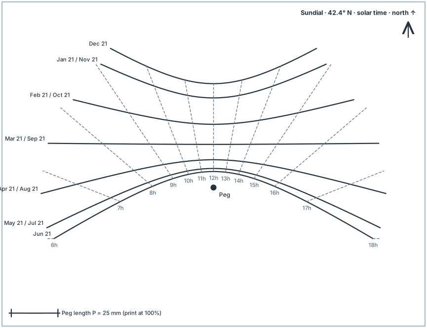
A horizontal sundial with a vertical peg of length P records the shadow-tip position for each date and solar hour. Fixed to a model, it sets the model to any sun position under one parallel light source.
- Print the sundial for the site latitude at 100 %. Check the scale bar: the peg length must equal P.
- Glue it to the model base with its north arrow on model north. Fix a peg of length P at the marked point.
- Place the model in direct sun or under a distant lamp. The farther the lamp, the more parallel the rays.
- Tilt and rotate the model until the tip of the peg's shadow touches the required date line and hour line. The model's shadows now correspond to that date and solar time.
CURRENT SHADOW TIP · P = 25 MM
Lines are drawn where ALT ≥ 15°. The downloaded file is in millimeters (print at 100 %).
8 QUESTIONS · CALCULATION AND CONCEPT
Self-test
"New values" generates a new variant of a calculation. Each answer shows a worked solution.
INSTRUCTOR & AUTHOR
About the instructor

EDITABLE VECTOR FILES
Figure files
Editable SVG files of every figure. Interactive drawings save their current state with "Save SVG".
- coordinates.svg · Fig. 1 · Latitude and longitude · LAT positive north; LONG in degrees west (°W), as in Eq. 2
- sky-dome.svg · interactive drawing, reference state · Sky hemisphere: ALT, AZI, ZEN
- world-time-zones.svg · interactive drawing, reference state · Standard-time zones of the world
- time-zones.svg · interactive drawing, reference state · Time zones and longitude correction
- orbit.svg · interactive drawing, reference state · Earth's orbit
- equation-of-time.svg · interactive drawing, reference state · Equation of time
- analemma-ithaca-noon.svg · interactive drawing, reference state · Analemma, Ithaca 12:00 EST
- declination.svg · interactive drawing, reference state · Declination over the year
- hour-angle.svg · Fig. 2 · Hour angle
- sundial-42N.svg · interactive drawing, reference state · Sundial for model testing, 42.4° N, print at 100%
SOURCES
Sources and model notes
- S. V. Szokolay, Introduction to Architectural Science, 3rd ed., Routledge, 2014. Sections 1.3.1, 1.4.1; Method sheets M.1.1 (solar geometry), M.1.2 (stereographic charts, shadow-angle protractor).Abbreviations, Eq. 7–9.
- N. Lechner, Heating, Cooling, Lighting, 4th ed., Wiley, 2015. Chapter 6 (solar geometry).Heliodons and sundials.
- J. A. Duffie, W. A. Beckman, Solar Engineering of Thermal Processes, Wiley.Spencer equation of time (Eq. 3), Cooper declination (Eq. 4).
- G. Z. Brown, M. DeKay, Sun, Wind & Light, 2nd ed., Wiley, 2001.Sundial for model testing.
- US Naval Observatory · The equation of time ↗Definition and range of EOT.
- NOAA · General solar position calculations ↗Higher-accuracy alternative to Eq. 3 and 4.
Model assumptions and precision
All interactive values use Eq. 3, 4, 6, 7 and 8 exactly as printed, with a 365-day calendar (2026). Cooper's declination formula and Spencer's equation of time are accurate to roughly ±0.5° and ±0.5 min; for design screening this is sufficient. Altitude is geometric: refraction (about 0.5° at the horizon) and the solar disk are ignored. Azimuth is undefined when the sun is exactly at the zenith.
Continue to Chapter 03: Drawing shadows by hand ↗